Kayah State, formerly Karenni State is bordered by Shan mountains to the north, Thailand's Mae Hong Son province to the east and Kayin (Karen) State to the south. It is the smallest among the seven states of Myanmar. The terrain is mountainous and is traversed by the Thanlwin (Salween), the principal river. The inhabitants of the state are Karens. The state is fairly well provided with Kyun (Teak wood) and other hard woods such as Pyinkado (Ironwood), Padauk and Ingyin. Other forest products are lac, resin and honey. Tin is found in the southern state. Marble is also a product of Kayah. Agriculture is one of the main economy of people. Rice, wheat, maize, millet, ground nut, sesame, cotton, soy bean, chilies, onions, garlic, tobacco, orange, banana and vegetables are grown. Myanmar's largest and most important hydro-electric power plant has been constructed at BaluChaung Waterfalls at LawPita some 12 miles south of Loikaw, capital of Kayah state.
How to get there:
Normally tourists could travel form Inle lake area using boat and car. The car roads from Taungoo (Bago division) and from Kayin state are not recommended due to lack of safety and bad road conditions. Loikaw is linked by the newly constructed Aungban-Pinlong-Loikaw rail line.Flights to Loikaw are made by Myanmar Airways Domestic which is seldom used by foreign tourists due to its bad safety record.
Loikaw:
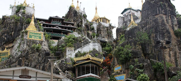
Is the capital of Kayah state. The famous religious landmark of Loikaw is the Thiri-Mingalar Taung-kwe Pagoda Hill, scenically built on a hillock overlooking the vast expanse of the environs. Around Loikaw visitors can visit Taungwe Pagoda (twin peaks of hills with a pagoda on top of each), two lakes and the market.
The revered names of some pagodas were: Shwe Yin Aye Ceti, Kyauk Thanban Ceti, Aung Taw Mu Ceti, Su Taung Pyi Ceti, Pyi Lone Chan Thar Ceti, Auk Kyaik Htee Yoe Ceti, Atet Kyaik Htee Yoe Ceti and Shwe Pyi Aye Ceti.There was a prophecy that one day the nine pagodas will be unified into one omniscient pagoda in the propagation and perpetuation of the Buddhist faith. The name of the sacred hill was also changed to Thiri-mangalar Hill in 1970. The next interesting place is called Htee-pwint-kan or Umbrella pond. It is situated in Demosoe Township in the heart of the paddy fields. It was just a small pond around a
hundred feet in circumference. The Kayahs believe that the present 'Htee pwint kan' is the pond dug by the crocodile with the help of the white buffalo. There is a legend about this pond. It says “Once upon a time in a dense forest a big white rabbit and a big crocodile lived together as friends. One day the rabbit told the crocodile that a severe drought would befall the following summer which would cause extreme hardship. The rabbit then persuaded the crocodile to leave the forest to more salubrious pastures where water was plentiful. Believing in the rabbit they both traveled till they reached atop a hillock when the rabbit ran away, leaving the poor crocodile to his dire fate. Luckily a white buffalo passed by and saw the predicament of the distraught crocodile, who requested the former to take him to where water was available. The buffalo replied that water was very far away. Then the crocodile suggested that the buffalo dig the earth with his strong hoofs, urinate on the earth to soften it and repeat the process again and again until the pit was deep enough for the crocodile to wallow inside. The buffalo obliged, and the crocodile wallowed until as luck would have it water spurted from the subterranean lake, bringing relief to the amphibian. The thankful crocodile offered to help the buffalo so that he may not suffer for want of water. Thus we now see that buffaloes never feel the scarcity of water as the crocodiles kept the promise made once upon a time.


